By Investigative Desk | Regional Environment & Policy News
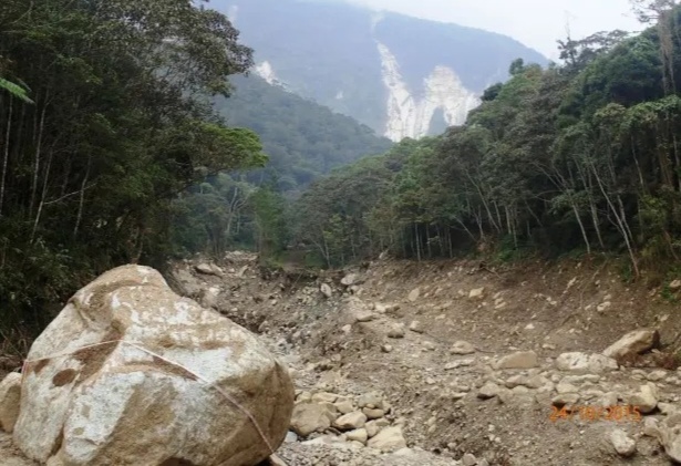
KOTA KINABALU — Residents living near the banks of the Mesilau and Liwagu rivers describe a terrifying acoustic phenomenon whenever torrential rains strike the foothills of Mount Kinabalu: a deep, subterranean roar as boulders the size of 4×4 trucks are dragged down the riverbed by fast-moving mudflows.
This violent grinding of stone against stone is the sound of an ecosystem undergoing structural collapse.
Decades of unrestrained commercial land clearing, intensive steep-slope vegetable farming in Kundasang, and unvetted tourist lodge construction—compounded by the enduring structural shock of the 2015 earthquake—have brought Sabah’s primary water catchment ecosystem to the brink of failure.
Without immediate political intervention to freeze high-altitude earthworks, execute rapid reforestation, and deploy dedicated local disaster units, civil engineers and environmental hydrologists warn that Sabah faces an irreversible 10-year countdown toward chronic water blackouts and catastrophic landslide disasters.
1. THE LOOMING TIPPING POINT: A MOUNTAIN LOSING ITS “SPONGE”
Mount Kinabalu and the surrounding Crocker Range massif have historically served as Sabah’s natural “water tower.” High-altitude montane cloud forests act as natural sponges, trapping fog drip and rainfall to regulate river baseflows during dry months while holding fractured geology in place.
However, historical logging throughout the late 1980s and 1990s stripped deep root networks along critical elevation corridors. In the decades since, intense agricultural conversion and rapid commercial development have further eroded these protective buffer zones.
When heavy downpours hit bare, high-gradient slopes, topsoil and loose aggregate do not absorb moisture—they liquefy. Thousands of tons of sediment, gravel, and massive car-sized boulders wash violently into primary drainage basins:
• The Liwagu / Sugut Basin: Supplying agricultural and domestic water to central and eastern Sabah.
• The Kadamaian / Tempasuk Basin: Feeding paddy fields and communities across Kota Belud.
• The Moyog Basin: Providing nearly 60% of the potable water supply for Greater Kota Kinabalu via the Babagon Dam catchment.
2. THE CHINA WARNING: A PREVIEW OF UNSTABLE SLOPES
The threat facing the Kinabalu foothills is not hypothetical. Recent catastrophic mountain slope disasters across Asia provide a stark preview of what happens when steep, fractured terrain is stripped of forest cover.
• In January 2024, a devastating landslide in Liangshui Village, Zhenxiong County, Yunnan Province, buried 18 homes and claimed 44 lives after heavy precipitation infiltrated fractured, steep rock structures.
• Later that year, torrential rains from Typhoon Gaemi triggered massive landslides in Hunan Province, killing dozens as destabilized slopes collapsed into inhabited valleys.
The geological profile of Kundasang and Ranau—marked by young, highly fractured sedimentary gravels, high annual rainfall, and extreme slope gradients exceeding 30 degrees—mirrors these disaster zones. Coupled with the lingering seismic damage from the 2015 earthquake, which stripped over 1,500 hectares of upper-elevation vegetation, the Kinabalu foothills sit on a geological fuse.
3. THE DOWNSTREAM REALITY: MUDDY TAPS AND SHUT TREATMENT PLANTS
Upstream landslips do not just threaten the immediate hillsides; they paralyze urban infrastructure dozens of kilometers downstream.
When tumbling boulders pulverize riverbeds during heavy rain, they create hyper-turbid slurries of silt and clay. Water turbidity levels routinely spike beyond the mechanical filtering capacity of major intake plants—such as the Bambangan Water Treatment Plant—forcing complete operational shutdowns.
For urban populations in Greater Kota Kinabalu, Ranau, and Kota Belud, this ecological decay translates into an immediate, recurring hardship: chronic water rationing, damaged pipelines, and economic disruption.
4. THE “BORNEO FORTRESS” EMERGENCY BLUEPRINT
To arrest this 10-year decline, environmental policy analysts and community advocates are calling for an emergency governance model titled the Borneo Fortress Initiative—a strategy that treats water security and slope stability as matters of state defense.
Pillar I: Immediate 10-Year High-Altitude Development Freeze
• Building Moratorium: State authorities must issue an immediate, strict freeze on all new earthworks, commercial tourist developments, and land clearances on slopes steeper than 20 degrees until a comprehensive 10-year Spatial Risk Masterplan is enacted.
• Agricultural Boundaries: Firm boundary caps must be established around commercial vegetable terracing in sensitive headwater corridors to prevent further encroachment into riparian reserves.
Pillar II: Bio-Engineering & Rapid Reforestation
• Native “Green Shields”: Mechanical retaining walls are insufficient against mass movement on this scale. The state must launch an aggressive bio-engineering initiative using deep-rooting native montane vegetation (such as native bamboo, wild figs, and Oak-Laurel forest complexes) to bind exposed topsoil and rebuild natural aquifer recharge networks.
• Mandatory Riparian Reserves: Re-establishing a mandatory 30-to-50-meter re-vegetated buffer zone along all streams cutting through agricultural land.
Pillar III: Dedicated High-Altitude Emergency Response in Ranau
• Localized Emergency Unit: Once geological danger zones are demarcated, a specialized Ranau Emergency Response Unit (ERU) must be permanently stationed in the district, equipped with specialized mountain search-and-rescue gear and heavy earth-moving equipment.
• Early Warning Telemetry: Installing real-time ground displacement and rainfall sensors across mapped high-risk zones to trigger automated evacuations before mudflows reach residential valleys.
• Community First-Responders: Formally training local mountain guides (malim gunung), farmers, and village leaders as certified first-responders to bridge the vital time gap between slope movement and state-level emergency deployment.
5. AN URGENT APPEAL TO THE STATE GOVERNMENT: TIME IS RUNNING OUT
The window for policy deliberation has closed. The physical evidence—from crumbling riverbanks in Kundasang to paralyzed water intake filters downstream—demonstrates that the Mount Kinabalu catchment is operating on borrowed time.
We issue a direct call to the Chief Minister of Sabah, the Ministry of Works, and the Sabah Water Resources Council: Immediate executive intervention is no longer an environmental request; it is a fundamental duty of public safety.
Using statutory powers under the Sabah Water Resources Enactment 1998 and the Environment Protection Enactment 2002, the State Cabinet must act immediately to:
Gazette High-Risk Catchments: Declare all un-gazetted headwater corridors around Mount Kinabalu and the Crocker Range as strict, protected Water Catchment Areas under Section 38 of the Sabah Water Resources Enactment.
Issue an Immediate Earthworks Moratorium: Order a complete halt on hillside cutting, earth-clearing, and unvetted structural development in Kundasang and Ranau pending independent geological safety audits.
Fund Emergency Slope Stabilization: Allocate direct emergency state funds for high-altitude bio-engineering, riverbed dredging, and the immediate setup of the Ranau Emergency Response Unit.
The Cost of Inaction: Every monsoon season passed without these protections increases the probability of a high-fatality slope failure mirroring those seen in Yunnan and Hunan. If the state delays until a major collapse occurs, no amount of disaster relief will bring back lost lives or restore a ruined water grid.
CONCLUSION: ACTION TODAY OR COLLAPSE TOMORROW
Mount Kinabalu cannot remain a passive icon of natural beauty while its buffer zones are systematically stripped for short-term gain. The choice before state planners and local government is clear: enforce bold, emergency environmental governance today, or pay an insurmountable price in lost infrastructure, water scarcity, and human lives over the next decade.